Historic environment and heritage management projects, resources, commentary and analysis by Professors Ian Baxter (Heriot-Watt University) & David Gill (Kent/UEA)
I ran an undergraduate business management module in the early 2000s at a previous University where I worked called ‘Enchanting the visitor’. At the time it was a very quirky addition to the degree module catalogue, but enjoyed by the group of tourism, travel, hospitality and cultural heritage students interested in the visitor experience of places and spaces and the ways in which it can be designed / curated and operationally delivered.
I loved teaching it (and may yet reprise it..). The notion of enchantment moving beyond the basic experiential reaction of a person to external stimuli has continuously lurked since at the back of my mind, as I have veered across teaching, research, practical delivery and consultancy in other areas of understanding and enhancing the visitor experience. The niggling notion of enchantment has been further informed and stimulated by my original training and continued love of archaeology; studying landscapes and reading nature writing; and in recent years obliquely putting a toe into the environmental humanities field (mainly through reading and attending seminars by people properly immersed in it).
The book Weird Walk (with associated website and journal) was in my Christmas pile, partly for novelty, but particularly as it very much chimes with the idea of enchantment in place – engaging with ancient places, archaeology, traditions and customs through the calendar year. Whilst not (yet) heading down the path toward more mystical engagement and spirituality, I am now diving into a wider literature search on enchantment (where defined differently from experience), to see where and if it has much objective consideration in the academic literature on heritage tourism sites. I’ll report back.
Four key reports are encouraging us to rethink heritage on both sides of the Thames Estuary. The RSA Heritage Index (2020) provides the data arranged by local authority to explore the contribution heritage makes in a locality. In particular, the accompanying report, Pride in Place by Hannah Webster, identifies the authorities along the Thames Estuary as having ‘heritage potential’. In other words, these areas rank highly in terms of heritage assets, but not so well in terms of heritage activities.
The RSA data for heritage in the two counties of Essex and Kent (and with sections on the Thames Estuary) are further explored in two reports by David Gill and Peter Matthews that have been issued by the Centre for Heritage at the University of Kent (2021). These three heritage reports can now be read against the Thames Heritage Levelling-up Data Atlas (2021) that was commissioned by the Thames Estuary Growth Board. This Atlas explores ten indicators in order ‘to help understand social outcomes and inequalities in a consistent way across the Estuary’.
Can the data from these reports form the starting point for interventions that would help to ‘level up’ local populations especially around the theme of health and well-being? This is particularly important as there is a strong correlation between higher levels of neighbourhood deprivation and lower arts, cultural and heritage engagement (Mak, Coulter and Fancourt 2021), and a significant body of research has demonstrated that the arts and culture can potentially impact both mental and physical health (Fancourt and Finn 2019).
In the Atlas section on ‘Health and Wellbeing’, Canterbury and Brentwood have the most active populations: only 17 and 20 per cent of the population take exercise for less than 30 minutes each week. (The average for England is 25 per cent.) Both these authorities perform well in the Heritage Index for England, ranking at 67 and 123. Specifically, Brentwood is ranked at 25 in the theme of Parks and Open Spaces, and at 95 for Landscape and Natural Heritage, while Canterbury is ranked at 223 and 35. While this could suggest that certain types of heritage asset promote good health through the provision of space for exercise, Castle Point is ranked at 52 in the Heritage Index, but 30 per cent of the population take exercise for less than 30 minutes each week.
The Atlas suggests that Canterbury, Dartford, Castle Point, Brentwood and Rochford, have better mental health than the average for England (17%); Canterbury, Rochford and Castle Point are in the top 100 in the Heritage Index for England. In addition, authorities in the Thames Estuary have a good level of Life Satisfaction with several authorities above the average for England (7.66 ex 10), notably Swale (7.78), Rochford (7.91), and Castle Point (7.99). This may reflect access to heritage assets. Rochford was ranked at 4 in the Heritage Index for Landscape and Natural Heritage; and Castle Point and Swale performed well in the rankings for Parks and Open Spaces (16/27) as well as Landscape and Natural Heritage (20/26).
The Levelling-up Atlas and the Heritage Index offer an invaluable starting point for understanding the link between heritage, and health and well-being. The data from the reports should be used by policy-makers to inform the levelling up agenda along the Thames Estuary, but it is clear that there needs to be further research into the way that local populations engage with heritage, and what can be done to improve the local assets for the wider benefit of the local population.
Professor David Gill (University of Kent) and Phil Ward (Eastern ARC)
This post was prepared for the Heritage Alliance debate, “Levelling Up: What does it mean for heritage?”, 30 November 2021.
The Blue Marine Foundation has recently published a report which considers the idea of National Marine Parks in the UK, and sets out proposals for how they might be established using local partnership models which build on current environmental protection designations.
Current landscape designations highlighted in report (Blue Marine Foundation)
The report recognises the opportunities which the pandemic has brought around raised recognition of environmental issues, and the opportunities which communities have with connecting or re-connecting in enhanced ways with the natural environment to promote wellbeing and generate sustainable economic benefits.
The report also highlights the relatively limited connections which many coastal communities have with management of the blue resource adjacent to them currently, and flags Plymouth Sound National Marine Park as a potential management model for increasing and widening stakeholder engagement in dynamic ways. It also highlights success of the World Heritage Site designation for the Jurassic Coast, generating £111 million annually for the economies of Dorset and Devon.
Recognition is made of the deep heritage connections which coastal communities have with the sea, and the proposed sites for National Marine Parks build on the distinct natural and cultural characteristics of these locations around the country.
The labelling of an area brings recognition and discussion, and the report’s proposals for National Marine Parks is an intriguing prospect which I hope will gain traction.
This wonderful series of essays—journeys in the title—transports us from Mousa Broch on Shetland, to Abbotsford in the Borders; from Bell Rock Lighthouse off Angus, to Sweeney’s Bothy on Eigg.
Kathleen Jamie ignites our imagination with her reflection on Geldie Burn, and more specifically Mesolithic sites in their landscape. Her essay on Maggie’s Centre in Fife makes sense of contemporary therapeutic space by comparing this location with the prehistoric site at Links of Noltland on Westray.
Some of the locations are well-known and perhaps to be expected: Calanais (James Robertson), Iona Abbey (Alexander McCall Smith), and Edinburgh Castle (Alistair Moffat). But there are some unexpected gems here: James Robertson in Innerpeffray Library.
I was surproisingly gripped by Alistair Mofffat on Glenlivet Distillery and Inchmyre Prefabs, and James Crawford on Hampden Park and Sullom Voe. They were reminders of how society can leave its mark on the built environment.
James Robertson’s essay on Auld Alloway Kirk not only explores Tam O’ Shanter, but also rural parish churches, for example at Kiltearn and Croick. Alexander McCall Smith reflects on the Italian Chapel on Orkney.
This creative volume provides a range of insights and voices on Scotland’s history.
Journal Summary: Time & Mind is interested in presenting new perspectives on, and approaches to, landscape, monuments, people and culture. The journal features scholarly work addressing cognitive aspects of cross-related disciplines such as archaeology, anthropology, folklore, sociology and psychology that can shape our understanding of archaeological sites, landscapes and worldviews. Time & Mind explores such diverse topics as archaeoastronomy, ecopsychology, sensory engagements with landscapes and monuments, and symbolic, religious and ritual landscapes in the past and present. It also explores how images of the past are created in, and shape, contemporary society through engagement with place.
Journal Summary: Landscape Research, the peer-reviewed journal of the Landscape Research Group, is a dedicated international forum for debating landscape. The journal is distinctive in its combining of high-quality and innovative research papers with reflective critiques of landscape practice.
Contributions to the journal appeal to a wide academic and professional readership and reach an interdisciplinary and international audience. Whilst unified by a focus on landscape, the coverage of Landscape Research is wide ranging. The journal therefore encourages submissions from a range of disciplines, including environmental conservation, geography (human and physical), landscape architecture, archaeology, history, anthropology, urban studies, planning, design, heritage studies, ecology, countryside management, cultural studies and forestry.
The Radical Road runs along the side of Salisbury Crags in Edinburgh’s Holyrood Park, providing panoramic views over the city of Edinburgh and its surrounding landscape. The path, which runs steeply along the face of the Crags, gained its name from unemployed weavers from the west of Scotland who were given work to pave the track following their failed efforts during the so-called ‘Radical War’ of 1820.
This insurrection arose as social unrest by workers who were fed up with poor working and living conditions from the government. A national strike which began in Glasgow on 3rd April 1820 spread, with protest leaders arrested in different parts of the country. Executions and transportation to the colonies was the result for some of them.
Following a Royal visit to the city by King George IV in 1822, Sir Walter Scott suggested that work could be given to unemployed weavers to build a footpath around the Crags, as part of an improvement for recreation in the Royal Park surrounding the Palace of Holyroodhouse.
The Radical Road has, however, been closed to all access since September 2018, following a major daytime rock fall, when over 50 tonnes of loose rock landed on and around the popular pedestrian pathway.
In March 2019, there were calls in the local press to reopen the route, but it remains closed with normally temporary barriers looking like permanent features. At the time of the last press coverage, Historic Environment Scotland which manages Holyrood Park commented:
“There have been a number of substantial rock falls from Salisbury Crags onto the Radical Road and surrounding area over the last few years with increasing regularity. Following the rock fall in September 2018, and with the continued risk of further rock falls, HES took the decision to close this path and adjacent desire routes to public access. These routes will remain closed while we assess the situation with advice from our geotechnical engineers. We are very conscious of the significance of Hutton’s Section and the desire for public access to it. However at present, visitor safety is our main concern.”
A further update appeared in the media in July 2019, following a BBC Freedom of Information request. This suggested that the path could be permanently shut amid fears on continuing and increased rock falls. Various options identified by consulting geotechincal engineers are requiring careful consideration given the high levels of visibility of the path given its height in the city’s landscape, its popularity as a recreational asset and the fact that Holyrood Park is scheduled as an Ancient Monument requiring specific management regimes. Given the deteriorating weather as Winter approaches, there is little prospect of access anytime soon and there have been few updates on the situation beyond the gnomic comment from Historic Environment Scotland that, “Due to the complexity of the situation, there is no specific timeframe at the moment”.
The situation in the Park is unfortunate, due to its ever-increasing popularity, the park being a superb recreational asset for the city, and desire for good viewpoints over the skyline of the city which is a key component of the Edinburgh destination image.
Such situations are likely to become more widespread though, given climatic changes and increased incidences of freeze/thaw cycles and heavy rainfall at different parts of the year. Balancing of access and health and safety, through risk analysis and environmental change risk modelling is high on the agenda for the heritage sector, but this is often thought of in more remote locations than the centre of the capital city. Historic Environment Scotland is at the forefront of thinking about this – as seen in the recent Climate Change Risk Assessment for its properties in care.
In Holyrood Park however, given its high level of expected accessibility by residents and visitors, there is perhaps therefore a case for a better interpretive strategy than simple warning barriers and notices currently provided, to bring the message of environmental threats and risks to the historic environment and otherwise taken-for-granted cultural landscapes to broader attention.
There has been much amusement in the media over the past few days around the official recording of a stone circle before Christmas by archaeologists from the local council and the national heritage organisation, Historic Environment Scotland, which has turned out to be only around 25 years old.
Described earlier as a smaller variation of sites typical of the region, it was noted that is was in very good condition, and that it was surprising that the site had not been formally recorded before now. The former owner of the land, however, has recently got in touch with the officials explaining that he built the replica in the mid-1990s.
Cue much collective guffawing and some professional embarrassment – neatly summed up on the BBC’s Newsround website as, “Awks!” The local archaeologist took to twitter noting ruefully, “If you are having an awkward day at work at least you’re not that guy who identified a new prehistoric stone circle to the press that now turns out to be about 20 years old.”
If you are having an awkward day at work at least you're not that guy who identified a new prehistoric stone circle to the press that now turns out to be about 20 years old. https://t.co/9EGmb9H3pO
A nice piece in the Scotsman this week puts this all into a wider perspective, noting that many archaeological sites of this kind remain mysterious; flags that the honesty and candour of professionals involved will do them good rather than harm; and that there is a history of making ‘new’ monuments. The example of the Sighthill Megalith is given – and I would encourage you to read Kenny Brophy’s blog on this site, and his other investigations into the past around us in the everyday urban environment.
I agree with the Scotsman article and forsee that the site will indeed become of greater interest to visitors, and should rightly do so. Given the ’30 year rule’ which applies to listing sites in the built environment, the site is already almost of an age where it could officially be ‘heritage’, and in due course could indeed merit protection – and why not? It may be a site of its time, and hopefully investigation won’t stop entirely – it would be great to professionally record the motivation of the builder of this new/old site – and, as archaeologists often say, to gain an insight into the society which created it – an advantage we don’t have for sites which really are 4000 years old.
Nether Largie South Cairn is part of the prehistoric landscape at Kilmartin. It was excavated by Canon Greenwell in 1864. Its first phase appears to belong to the early Neolithic. Two cists were cut into the outer part of the cairn, probably ion the Early Bronze Age.


 The Radical Road has, however, been
  In Holyrood Park however, given its high level of expected accessibility by residents and visitors, there is perhaps therefore a case for a better interpretive strategy than simple warning barriers and notices currently provided, to bring the message of environmental threats and risks to the historic environment and otherwise taken-for-granted cultural landscapes to broader attention.
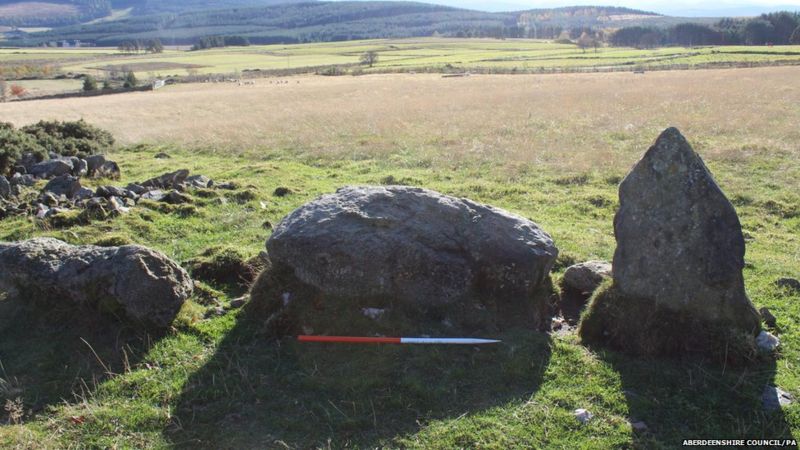 There has been much amusement in the media over the past few days around the official recording of a stone circle before Christmas by archaeologists from the local council and the national heritage organisation, Historic Environment Scotland, which has

